Page 47 - COPA_July2023
P. 47
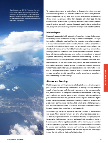
 Thunderstorm over SPE (St. Petersburg-Clearwater Int’l in Florida) Daytime heating of the land can draw warm, humid air onshore and lift it to produce cumuli, rain, and if conditions are right, thunderstorms along the sea breeze front. Pilots should avoid flying within 20 miles of any thunderstorm.
To make matters worse, when the foggy air flows onshore, the rising and sometimes rough shore can force the air to lift and cool further, thicken- ing and deepening the fog layer. Also, unlike radiation fogs, moderate to strong winds can enhance rather than dissipate advection fogs. It is not uncommon for an advection fog to bring zero/zero conditions that extend several hundred feet aloft. However, like sea breeze fronts, advection fogs are usually well forecast as they are driven by larger-scale weather patterns.
Marine layers
Frequently associated with advection fog or low stratus decks, many coastal regions are prone to developing so-called marine layers. This layer forms when cold water saps heat from the overlying atmosphere, creating a shallow temperature inversion beneath which the surface air continues to cool. If the humidity is high enough, this process will produce fog or low clouds, but in areas of low humidity, the marine layer may remain clear, although pilots will find some turbulence around the inversion. A marine layer will also normally decrease land surface temperatures by several degrees, ameliorating otherwise intense summer heating. Usually, an approaching front or strong pressure gradient will dissipate the marine layer.
Marine layers can be more difficult to predict, as their formation and dissipation depend on several factors, including atmospheric instability, winds, the development of a sea breeze circulation, and even what is occur- ring in the upper troposphere. However, when a marine layer is forecast or reported, pilots should expect that coastal airports may experience reduced visibility and low ceilings.
Storms and flooding
Maritime cyclones, both tropical and extratropical, pose a direct danger to pilots flying in and out of many coastal areas. Fueled by a virtually unlimited supply of latent energy, such storms bring extreme winds, heavy precipita- tion, hail, turbulence and frequent embedded thunderstorms. Fortunately, such cyclones are usually seasonal, and pilots can take precautions to protect their aircraft on the ground at coastal airports and avoid flights during the storm passage. Wintertime marine cyclones can be especially problematic as the ample moisture, high winds and cold temperatures can bring blizzard conditions, or produce freezing rain or fog that results in rapid ice accretion on parked or taxiing aircraft.
An increasingly disruptive aspect of maritime cyclones is tied to rising sea levels. Many coastal runways are only a few feet above sea level. As a result, high tides are now a “nuisance,” flooding low-lying airports, temporarily shutting down runways and even flight operations. Matters become worse when a high tide coincides with a storm surge of seawater from an approaching cyclone. This situation can increase airport flooding by several feet, inundating runways and rendering airport access roads impassable. Pilots flying from these low-elevation airports are encouraged to add the tide tables to their preflight planning.
 VOLUME 18, NUMBER 7
45
PILOT POINTERS


